Thursday, April 13, 2006
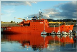
AURORA AUSTRALIS

Monday, April 10, 2006
TAHUNE AIRWALK
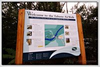
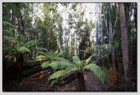
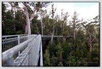
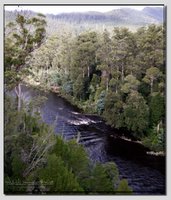
The 597 metre long Air Walk, situated in the Tahune State Forest, provides visitors with a magnificent view or the environment. Visitors can also view Tasmania's famous Huon Pine and relax in the comfort of the unique centre where they can sample a taste of the Huon Region.The Tahune Forest Reserve was chosen as the Air Walk site due to its unique location at the confluence of the world renowned Huon and Picton Rivers, bounded on both sides by magnificent eucalypt forest.

The area already has an estimated visitor profile as a venue for four wheel driving, rafting, bushwalking and fishing. Its central location also provides a hub from which visitors can experience a range of cultural, heritage and recreational activities in the Huon Valley.Not only has the project met the highest environmental standards, the Visitor Centre also sells gourmet food and retail products supplied by the region's top producers, in turn providing them with the opportunity to increase their profile and establish a reputation for excellence and quality.
The Air Walk structure itself has been made in Tasmania and designed to meet the highest safety standards. The steel framework is supported by 12 towers embedded in the forest floor with a concrete plinth with a further three elastic steel guy cables, specifically designed for the project, attached to each tower. The walk is built to withstand winds up to 180 km.
Thursday, April 06, 2006
PORT ARTHUR
HOBART
Hobart is located on the estuary of the Derwent River in the state's south-east at 42
The Port of Hobart occupies the whole of the original Sullivan's Cove.
The Greater Hobart Metropolitan area consists of three self-governing cities, Hobart, Glenorchy and Clarence, plus the urbanised areas of the Municipalities of Kingborough and Brighton. The suburban areas cover a significant
Apart from the city, the main commercial centres are Glenorchy (the northern suburbs) and Rosny (the eastern shore). The satellite town Kingston, south of the city, is fast becoming an outlying suburb of Hobart. Other surrounding towns such as Sorell, Margate, Brighton and New Norfolk are popular residential areas for commuters.
Hobart has a mild temperate oceanic climate, with four distinct seasons. The highest temperature recorded was 40.8°C on 4 January 1976 and the lowest was -2.8°C on 25 June 1972.
BICHENO
Bicheno was established as a whaling centre as early as 1803. It was at this time that the sealers and whalers arrived and began using Waubs Boat Harbour (the old name for Bicheno) as a base for their activities on the east coast. The sealers and whalers actually predated the first official settlement of Van Diemen's Land. They lived a primitive and dangerous life and were known to be particularly cruel to the local Aborigines who they enslaved and prostituted.
The use of Bicheno as a coal port was short-lived. The discovery of gold in Victoria saw most of the town's residents depart in 1855 and for nearly a century Bicheno became a sleepy little fishing village.
Fishing has continued to be the lifeblood of the town and although, in recent times, it has become a popular tourist destination, there are still many fishing vessels moored in the town's harbour. The local fishing industry's catch includes substantial quantities of abalone, crayfish, scallops and trevally. Tourists are also able to observe Penguins late in the evening along the beach in Bicheno.
SPIRIT OF TASMANIA
The first ship, Spirit of Tasmania started sailing in 1993. It sailed three return trips a week between Devonport, Tasmania and Station Pier in Melbourne, Victoria. The crossings were overnight and took approximately 15 hours. In 2002, Spirit of Tasmania was de-commissioned, and sold to the Fjord Line company in Norway
The original Spirit was replaced with two ships Spirit of Tasmania I and Spirit of Tasmania II, which were purchased from Superfast ferries in Greece - formerly Superfast III and Superfast IV. They travel the same Devonport-Melbourne route, however each ship makes one trip each night, taking only ten hours. In peak periods, the ships also make day crossings. The introduction of these two ship have played a major role in giving the Tasmanian tourism industry a much needed boost. Before the introduction of these two vessels, many potential travellers had difficulty booking on the old "Spirit of Tasmania" due to capacity constraints. These new vessels have removed the bottleneck for tourists trying to reach the state and their unhindered access has resulted in a thriving tourism industry.
Spirit of Tasmania III began service in 2004. It is also a Superfast ferry
RICHMOND
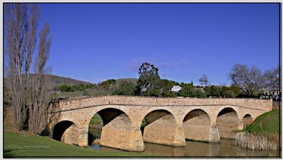 Richmond, Tasmania is a town about 25 km north-east of Hobart, in the Coal River region, between the Midlands Highway and Tasman Highway.
Richmond's most famous landmark is the Richmond Bridge, built in 1823, around the time of the town's first settlement. It is Australia's oldest bridge still in use.
The town was initially part of the route between Hobart and Port Arthur until the Sorell Causeway was constructed in 1872.
Present-day Richmond is best known as being preserved as it was as that time. It is a vibrant tourist town, with many of the sandstone structures still standing.
BRUNY ISLAND
Geologically, Bruny Island is actually comprised of two islands - North Bruny and South Bruny - that are joined by a long, narrow sandy beach. The holiday village of Dennes Point is located in North Bruny, while South Bruny is the site of the towns of Alonnah, Adventure Bay and Lunawanna.
Outside its settlements the island is covered in grazing fields and large tracts of dry eucalyptus forest. Inland forests continue to be logged, but other large sections - mostly along the southeastern coast - are preserved as the South Bruny National Park. While the seaward side of the island features two long beaches - Adventure Bay and Cloudy Bay - it is for the most part extremely rugged, with cliffs of dolerite that tower over 200 metres above sea level, and which are amongst the highest sea cliffs in Australia.
Bruny's channel side is far more sheltered and a favourite fishing and recreational boating area for local and interstate visitors.
MOUNT WELLINGTON
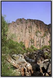
Mount Wellington is the mountain on whose foothills is built much of the city of Hobart. It is frequently snow covered, sometimes even in summer. It is often referred to simply as 'the Mountain' by Hobartians, and it rises to 1,271 metres above sea level.
The lower slopes are thickly forested, but criss-crossed by many walking tracks and a few fire trails. There is also a sealed but narrow road to the summit, about 22km from the city. Halfway up this road is a picnic area called "The Springs", near the site of a chalet/health spa that was destroyed by a bushfire in 1967.
An enclosed lookout near the summit provides spectacular views of the city below and to the east, the Derwent River, and also glimpses of the World Heritage area nearly 100 km to the west.
From Hobart, the most distinctive feature of Mt. Wellington is the cliffs of dolerite columns known as the Organ Pipes.
The mountain significantly influences the city's weather, and intending visitors to the summit are advised to dress warmly against the often icy winds at the summit, which have been recorded at over 135km/hr.
The first weather station was set up on Mount Wellington in 1895 by Clement Lindley Wragge.
A cable car development has been proposed for the mountain on various occasions, but public oppostion has so far prevented any major developments.

FRANKLIN SQUARE
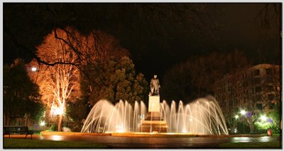 Located in the centre of Hobart and surrounded by Macquarie, Elizabeth and Davey Streets, this was the site of the first Government House.
Magnificent oak trees provide shade for visitors who have come to enjoy the area. A central feature of this site is the majestic fountain. A statue of Governor Sir John Franklin stands in the square.
There is ample seating and public convenience facilities are located on the Elizabeth Street frontage of the Square.
HOBART PANORAMIC
Wednesday, April 05, 2006
WELCOME

Welcome to my "Images of Tasmania" blog. What I plan to do here is showcase some of my photographs taken since moving to Tasmania in 2005. My husband Andrew and I had an opportunity to move to Hobart from the Whitsundays, and we didn't look back.
Okay, for those so inclined, I'm shooting on a Canon 20D digital SLR camera, which offers me 8.2 mega pixels, which is great for getting some of my images printed quite big. Andrew re-kindled my interest in photography after dragging me to many camera shops with his intent to buy a 35mm SLR. Later in the year we will buy another DSLR to keep Andrew occupied also!
Well please feel free to enjoy my images of my beautiful home of Tasmania. As we travel more around the State I will continue to add images.
Thanks!
Kel
